It was all street directories and GPSs before
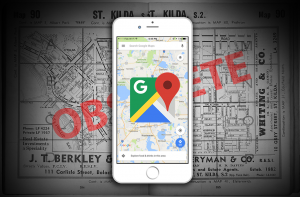
Growing up, I’ve lived in the era of street directories just before they, thankfully, got succeeded by GPSs. They were those books you had to buy every 6-12 months since new streets would be added or businesses would change addresses. It was essential that you had one, usually in the glove box of your car. Now I wasn’t old enough to drive when people were still using them, but I could only imagine how annoyed a driver would be trying to read one while driving especially if they didn’t have a passenger to help guide them. For me, I found them incredibly frustrating despite how much we depended on them. This was because you could only see one section of the map per page and you were given a page number to go tediously looking for the adjacent section.
GPS Tracking
Then around 2006 came GPS tracking devices that you could put in your car. That was a step in the right direction. As the name suggests, it made it so much more convenient to track your location in real time. Many different companies started appearing out of nowhere and creating these. I grew up with a TomTom and you were able to use different voice assistants. In fact, the one I used to have had Darth Vader as a voice assistant. It was very cool. Unfortunately, GPSs were generally quite slow and clunky. They also often had very confusing interfaces. Sometimes they would even lead you through bad roads and longer routes; not so helpful.
People started wondering about having maps on their phones.
Well it took the invention of the first iPhone for that to happen. The first iPhone came with Google Maps, which was seriously ahead of its time, and this was only in 2007! Because people were finally able to use their phones for directions, it could automatically update the app. People could view the most up-to-date information and businesses could freely update their addresses if necessary or add opening hours.
Google Maps today
Nowadays, everyone is using Google Maps on their phones. Feature after feature have been added since the initial launch 11 years ago and people have been depending on it for just about everything. From finding times when a shop opens and closes, when their next bus is due, to even viewing a fully 3D model of a city! When I first got Google Maps on my phone, many years ago, I was blown away by the technology. Suddenly, I could just go to Paris and look at the Eiffel tower through Street View on my phone and travel through the city. This is something Google’s competitors didn’t have. Nowadays, if you were to ask anyone to install a TomTom mapping software on their phone, they would look at you confused and wonder why they should when they have Google Maps. Google Maps succeeded in knowing what the user really needed and how to deliver it.
The next thing to do with Google Maps – adding data
Thanks to Google Maps, we were able to create CRM-Map. CRM-Map is a revolutionary new tool that helps businesses use their data in the most effective way. Businesses can now get the wow factor with their data and see it on the map! Our parent company, Accede, has been in the IT industry for over 35 years providing database solutions that are efficient, effective and of value. So they understand what businesses want. Which is why they’ve created CRM-Map.
 Mozilla Firefox
 Google Chrome
 Microsoft Edge
 Apple Safari